
GIS Programming and Software Development

Credit: High Angle View of Residential Buildings by Palo Cech is free to use
Resource Description
Bill Gates is credited with saying he would "hire a lazy person to do a difficult job" with the justification that "a lazy person will find an easy way to do it." GEOG 485 doesn't teach the lazy way to get the job done, but it does teach the scripting way — which is arguably even better. You've probably heard the "give a fish"/"teach to fish" saying? That's the gist of GEOG 485: to equip you, in an ArcGIS context, with the ModelBuilder and Python scripting skills to make your boring, repetitive geoprocessing tasks easier, quicker and automatic — so you can focus on the more interesting (potentially more valuable) work that you (and your employers) really want you to be doing. Learn moreIndependent Study in Geospatial Intelligence

Credit: Photo by Christopher Gower is free for use
Resource Description
Independent Study is an opportunity for students to work with individual direction from a faculty member on a topic of mutual interest in geospatial intelligence. Students must have strong professional experience or have taken courses in the subject matter leading up to the chosen topic. Independent Study is reserved for advanced specialties or for intermediate study in areas in which the department does not normally offer course work. Faculty members are under no obligation to accept Independent Study students, but do so as their teaching load permits. This option allows students to complete some of their credit requirements by studying on their own. Learn moreIntelligence Analysis, Cultural Geography, and Homeland Security
Resource Description
GEOG 571 explores the relationships between culture and civil security and the process of geographically analyzing social, political, economic, and demographic information to understand human history, institutions, and behaviors. It is an elective course in the Geospatial Intelligence Certificate, the Intercollege Master of Professional Studies (iMPS-HLS), and the Master of Geographic Information Systems degree program that is offered exclusively through Penn State's World Campus. It is also one of the optional capstone courses that leads to Penn State's Postbaccalaureate Certificate in GIS. The course consists of projects, associated readings, and exams. Learn moreLocation Intelligence for Business

Credit: Aerial Photography of Cars on Road-intersection 186537/ by Joey Lu is licensed under CC0 | location pins added to original
Resource Description
Do you enjoy the competitive challenge of starting up a new business or expanding into new areas? Are you involved in economic and community development? Are you considering the best place to work and live? Do you like to gain an advantage? Location Intelligence for Business extends the application of geospatial intelligence analytical methods to the business world for competitive advantage. You will have an opportunity to understand and apply location technologies, geospatial analysis, and business geography (demographics and psychographics) to support competitive business decision-making. You will uncover and explore the key geospatial principles involved in site selection, market analysis, risk and crisis management, logistics, and transportation by solving those problems with available geospatial tools and data. Learn moreMaking Maps that Matter with GIS
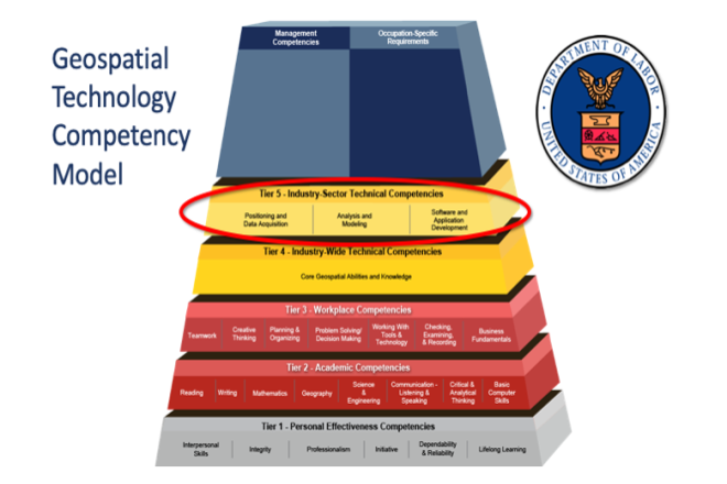
Credit: US Department of Labor Employment & Training Administration - Used with Permission
Resource Description
This open courseware consists of eight videos from the gateway course to Penn State's Certificate and Masters degree programs in GIS. Following an introduction entitled “Why GIS Matters," six case studies correspond to the three sectors of the U.S. Department of Labor’s Geospatial Technology Industry: 1. Positioning and Data Acquisition (“GIS and the Eradication of Polio in Nigeria” and "A Global Geodetic Reference Frame for Sustainable Development”) 2. Analysis and Modeling (“Everyday Spatial Analysis” and “A National Water Model for Flood Prediction and Response”) 3. Software and App Development (“Rediscovering GIS” and “Building a Web GIS Business) The concluding video "Will GIS Matter in the Internet of Things?” considers the future of GIS technology and prospects for GIS people. Making Maps that Matter with GIS Video Playlist Learn moreOpen Web Mapping

Credit: The Activities of Africa by Mariusz Prusaczyk is licensed under CC0
Resource Description
Everyone can make a web map now, but what are the best tools to do so? Maybe you have already created web maps with ArcGIS or Google Maps but never taken time to have a closer look at open source software alternatives such as QGIS, GeoServer and Leaflet? Or, are you new to web mapping and looking for the best way to create a web application for spatial data from your job or hobby? If so, GEOG 585, Open Web Mapping, is the right course for you. Learn about FOSS vs. proprietary GIS software, open data and standards for web mapping, and how to create beautiful and interactive web maps with Javascript and Leaflet. Learn moreSpatial Data Science for Emergency Management

Credit: Helicopter Help First Aide by ThePixelman is licensed under CC0
Resource Description
Geospatial perspectives and technologies play a major role in planning for and responding to emergencies. Geospatial tools - from aerial mapping techniques to data acquisition, are changing rapidly as is emergency management as the frequency and magnitude of crises and disasters are increasing. This course provides an understanding of how geospatial perspectives and technologies support all stages of emergency management activities, from small scale emergency management efforts to large scale disaster/humanitarian efforts. This includes learning about commonly used and emerging geospatial tools. It also includes an exploration of advancements in data collection, processing and analysis capabilities, such as unmanned aerial systems, geospatial artificial intelligence, volunteered geographic information, social media, and many more. Learn moreSpatial Database Management
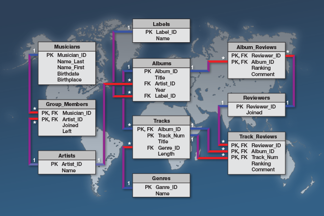
Credit: © Penn State University is licensed under CC BY-NC-SA 4.0
Resource Description
A spatial database is the backbone of a successful organization or website that depends upon maintaining and using data pertinent to locations on Earth. In GEOG 868, Spatial Database Management, capabilities specific to Relational Database Management Systems (RDBMS) and Geographic Information Systems (GIS) are combined to teach students to create, maintain, and query spatial databases in both desktop and enterprise environments. Learn the basics of Standard Query Language (SQL) and database design/normalization, the specifics of managing spatial data in an open-source technologies context (Postgres/PostGIS) and in the context of the Esri geodatabase. Along the way, you will become familiar with spatial functions and versioning, the latter in a server environment hosted by Amazon Web Services. Learn moreUnmanned Aerial Systems

Credit: Photo by JESHOOTS.COM is licensed under CC0
Resource Description
Unmanned Aerial Systems, or drones, are developing aggressively, and many government and non-government agencies are considering acquiring such systems. This course will focus on the geo-spatial utilization of a UAS. It will cultivate students' knowledge of the capabilities and limitations of the UAS and data post-processing systems. It introduces fundamental concepts surrounding operating a UAS such as strategies for selecting the right UAS, assessing its performance, managing resulting products (i.e. imagery), selecting the appropriate commercially available processing software, assessing product accuracy, figuring ways and means of producing metric products from UAS, and understanding rules and regulations governing operating a UAS in the United States. Learn moreWeb Application Development for the Geospatial Professional

Credit: Ipad, Map, Tablet, Internet, Screen by FirmBee is licensed under CC0