
GIS Programming and Software Development

Credit: High Angle View of Residential Buildings by Palo Cech is free to use
Resource Description
Bill Gates is credited with saying he would "hire a lazy person to do a difficult job" with the justification that "a lazy person will find an easy way to do it." GEOG 485 doesn't teach the lazy way to get the job done, but it does teach the scripting way — which is arguably even better. You've probably heard the "give a fish"/"teach to fish" saying? That's the gist of GEOG 485: to equip you, in an ArcGIS context, with the ModelBuilder and Python scripting skills to make your boring, repetitive geoprocessing tasks easier, quicker and automatic — so you can focus on the more interesting (potentially more valuable) work that you (and your employers) really want you to be doing. Learn moreSpatial Database Management
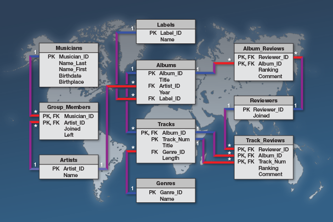
Credit: © Penn State University is licensed under CC BY-NC-SA 4.0
Resource Description
A spatial database is the backbone of a successful organization or website that depends upon maintaining and using data pertinent to locations on Earth. In GEOG 868, Spatial Database Management, capabilities specific to Relational Database Management Systems (RDBMS) and Geographic Information Systems (GIS) are combined to teach students to create, maintain, and query spatial databases in both desktop and enterprise environments. Learn the basics of Standard Query Language (SQL) and database design/normalization, the specifics of managing spatial data in an open-source technologies context (Postgres/PostGIS) and in the context of the Esri geodatabase. Along the way, you will become familiar with spatial functions and versioning, the latter in a server environment hosted by Amazon Web Services. Learn moreWeb Application Development for the Geospatial Professional

Credit: Ipad, Map, Tablet, Internet, Screen by FirmBee is licensed under CC0